Overview of Commercial Real Estate Drone Photography
Commercial real estate drone photography has revolutionized how property portfolios are showcased and marketed. By integrating advanced drone technology into the real estate sector, professionals are able to capture high-resolution aerial images and videos that provide prospective buyers and tenants with a comprehensive perspective of a property's layout, surroundings, and architectural details. Unlike traditional photography methods, drone-based imagery offers dynamic vantage points, highlighting aspects such as outdoor amenities, landscape features, and overall property scale with unprecedented clarity and precision.
In the context of commercial property marketing, drone photography facilitates the creation of compelling visual narratives. These visuals are instrumental in attracting investment, fostering faster lease agreements, and elevating online property listings. Aerial imagery immerses viewers, enabling them to appreciate the full scope of complex sites, including large industrial facilities, office campuses, retail complexes, and multifamily developments.
The advantages extend beyond marketing benefits; drone photography streamlines property inspections, provides data for site planning, and enhances virtual tours, thus reducing the need for physical visits. The ability to generate engaging, high-definition content quickly and efficiently allows real estate professionals to stay competitive in a rapidly evolving marketplace.
Overall, commercial real estate drone photography serves as a strategic asset for real estate firms aiming to elevate their marketing campaigns and provide detailed, comprehensive portrayals of property assets. Its effective deployment can transform standard property listings into captivating visual stories that resonate with target audiences and drive business growth.
Legal and Regulatory Considerations
When employing drone photography for commercial real estate in Miami, it is essential to understand the framework guiding drone operations. The Federal Aviation Administration (FAA) provides comprehensive guidelines that govern the use of unmanned aircraft systems (UAS) in commercial settings. Operators must obtain certifications, such as the Part 107 license, demonstrating their knowledge of airspace rules, safety protocols, and operational limitations.
Adhering to airspace classifications and restrictions in Miami is crucial. Certain areas, including airports, military zones, and designated wildlife refuges, require special permissions or must be avoided altogether. Local policies in Miami may impose additional requirements, such as obtaining permits or coordinating with city authorities before conducting aerial flights. This ensures that drone activities do not interfere with other airspace users or infringe upon privacy norms.
Furthermore, operational safety mandates emphasize maintaining visual line-of-sight, avoiding obstacles, and flying within specified altitude limits. Regular drone maintenance and operator training further underpin compliant operations. These practices help ensure that commercial real estate drone photography in Miami meets all regulatory expectations while capturing high-quality, impactful visuals.
Employing professionally licensed drone operators who are familiar with Miami’s specific regulations not only safeguards compliance but also enhances the credibility and safety of the project. This diligence supports seamless integration of aerial imagery into marketing campaigns, virtual tours, and property assessments, thereby optimizing the overall effectiveness of drone-based property promotion.
Legal and Regulatory Considerations
Executing commercial real estate drone photography in Miami requires meticulous attention to an array of established operational standards and regulatory frameworks. Precision in adhering to airspace classifications, local ordinances, and property rights is essential for maintaining both safety and professionalism. Operators must familiarize themselves with Miami's specific airspace restrictions, including zones around airports, military installations, and environmentally protected areas, which often necessitate coordinated permissions or special authorizations before conducting flights.
In addition to airspace management, local policies may impose unique requirements, such as obtaining permits directly from municipal authorities or scheduling flights within designated hours to minimize disturbance. It is crucial that drone operators keep abreast of these guidelines and cooperate with relevant agencies to ensure seamless operational execution. By doing so, they prevent unnecessary interference with other airspace users and uphold respect for privacy boundaries, fostering community trust and client confidence.
Operational safety remains a cornerstone of compliant drone activities. This involves maintaining clear visual line of sight with the drone at all times, ensuring flight paths are free from obstacles such as power lines and tall structures, and adhering to prescribed altitude limits that guarantee safe operation within the local environment. Regular maintenance routines for drones, including sensor calibration and battery checks, are vital for preventing technical failures mid-flight. Additionally, comprehensive training for drone pilots enhances their ability to navigate complex urban terrains safely and efficiently.
Employing licensed and seasoned drone operators who understand the intricacies of Miami’s airspace policies and safety protocols not only ensures compliance but also improves the quality of captured imagery. Such expertise enables the integration of aerial views into a variety of marketing tools — from virtual property tours to detailed site analyses — ultimately amplifying the visual appeal and marketability of commercial properties. Adherence to these guidelines facilitates a smooth workflow, minimizes risks, and maintains professional standards vital for high-stakes real estate promotional efforts.
Utilizing Legitimate and Reliable Equipment
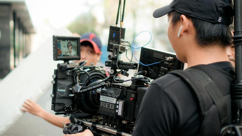
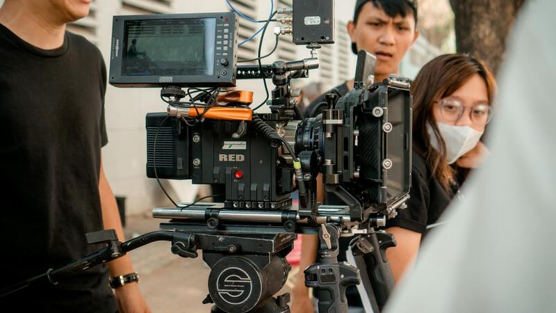
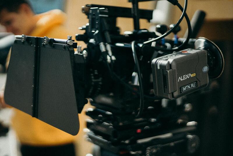
For high-quality commercial real estate drone photography, leveraging state-of-the-art equipment is essential. Professionals utilize top-tier drones equipped with high-resolution cameras capable of capturing crisp, detailed images and videos that accurately represent property features. These drones often incorporate advanced stabilization systems and gimbal technology, ensuring smooth footage even in challenging weather conditions or uneven terrain. Additionally, selecting drones with high dynamic range (HDR) capabilities allows for balanced exposures, highlighting both shadowed and brightly lit areas efficiently.
Camera setups are tailored to the specific requirements of commercial property photography. Wide-angle lenses are typically used to showcase the entirety of large estates or expansive facilities, providing viewers with a comprehensive perspective. For interior shots, drones equipped with adjustable apertures and zoom features facilitate detailed captures of interior layouts without compromising image quality.
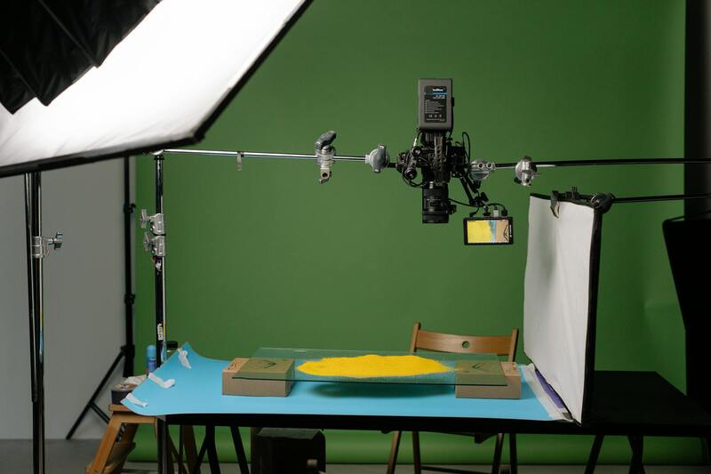
Advanced Software and Post-Production Tools
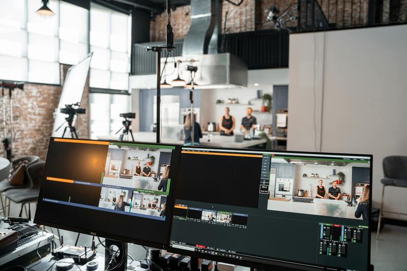
Modern commercial drone operations rely heavily on sophisticated software to plan flight paths meticulously. Mapping tools enable precise route creation, ensuring optimal coverage of the property and its surroundings. Once footage is captured, professional editing software is used to enhance images and videos by adjusting brightness, contrast, and color balance, ensuring the visuals meet the highest standards of clarity and appeal.
Image stitching software plays a vital role in creating panoramic views and high-resolution aerial maps, which are particularly beneficial for large complexes or multifaceted properties. These detailed visual materials support marketing efforts by providing comprehensive views that might be challenging to produce through traditional photography methods.
Ensuring Accuracy and Consistency in Visual Content
To maintain a standard of quality and consistency across all marketing materials, practitioners employ calibrated equipment and standardized shooting protocols. Consistent lighting conditions and time-of-day considerations help produce uniform shots, essential for visual coherence across listings and promotional campaigns.
The use of GPS geo-tagging and metadata embedding further enhances the professionalism of the content, allowing precise location referencing and easier integration into virtual tours, property websites, and other marketing channels. Maintaining such standards ensures the content remains reliable and professionally curated, boosting client confidence and engagement.
Equipment and Technology Used in Commercial Real Estate Drone Photography
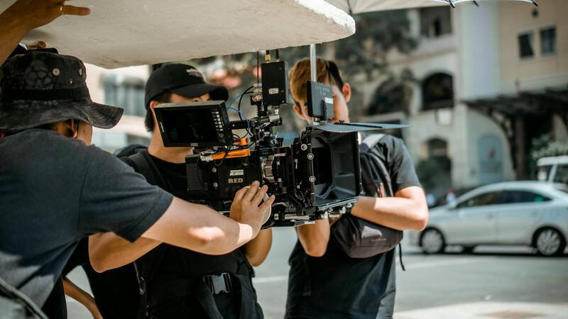
Implementing drone photography for commercial real estate hinges on utilizing top-tier equipment and cutting-edge technology to achieve high-quality visuals that accurately represent properties. High-resolution professional drones are engineered with advanced stabilization mechanisms, allowing for smooth flight and crisp image capture even in challenging wind conditions. These drones are often equipped with dual gimbal systems to ensure steady footage from multiple angles, providing comprehensive coverage that highlights the property’s appeal from various perspectives.
Cameras mounted on these drones typically feature large sensors, high megapixel counts, and wide-angle lenses to capture detailed images and videos. The use of 4K or 6K video recording capabilities ensures that footage remains sharp and usable for professional marketing and promotional materials. Additionally, multi-spectral imaging sensors are available for specialized applications, such as assessing land gradients, material conditions, or vegetation health around the property.
State-of-the-art flight controllers equipped with GPS and obstacle avoidance systems enhance safety and operational precision. These systems enable autonomous flights, waypoints, and geofencing, which are crucial for executing complex shot plans within regulated environments. Night-vision or infrared cameras expand operational hours and enable surveillance in low-light conditions, broadening the scope of possible projects.
Supplementing drone hardware are advanced accessories such as polarized lenses, which reduce reflections and glare, and filters to improve image quality under specific lighting conditions. High-capacity batteries permit longer flight times, often exceeding 30 minutes per charge, maximizing efficiency during shoots. For professional workflows, ground stations with real-time video feeds allow pilots and clients to monitor footage live, facilitating immediate feedback and adjustments.
Equipment and Technology Used
To achieve high-quality aerial imagery of commercial properties, professionals rely on a comprehensive array of advanced drone equipment and supporting technologies. Modern commercial-grade drones are equipped with high-resolution cameras capable of capturing detailed images and videos from various altitudes, providing comprehensive perspectives that enhance property presentations. These drones often feature stabilization gimbals that ensure smooth footage, even in windy conditions, which is essential for producing professional-grade content.
Specialized sensors further expand the capabilities of commercial drones. For instance, multispectral and thermal imaging sensors facilitate land analysis, irrigation mapping, and material assessments that are valuable during property due diligence and planning phases. LiDAR sensors provide precise topographical data, enabling accurate land surveys and 3D modeling, critical components in large-scale real estate projects.
The flight controllers embedded within these drones are designed with sophisticated GPS and obstacle detection systems, such as ultrasonic sensors, infrared detectors, and visual sensors. These features enable autonomous flight modes, precise waypoint navigation, and safe operation within complex urban environments. Moreover, geofencing capabilities restrict drone operations to designated areas, ensuring compliance with flight boundaries.
Battery technology has also seen significant advancements, with high-capacity, quick-charging batteries allowing for extended flight sessions that can last from 20 to over 30 minutes per charge. This increased endurance permits extensive coverage of large properties without frequent interruptions.
On the ground, operators utilize ground stations equipped with live video feeds, enabling real-time monitoring and immediate assessment of shot quality. This communication system ensures that modifications to flight paths or camera settings can be made instantaneously, maximizing efficiency and precision.
Supplementary accessories like polarized filters help reduce glare and reflections, crucial when capturing reflective surfaces such as glass facades and water features. Filters for different lighting conditions also ensure optimal image clarity and color accuracy. These technological considerations collectively contribute to producing visually compelling images that meet the standards of commercial real estate professionals.
Legal and Regulatory Considerations
Adherence to established procedures and regulated standards is paramount when executing commercial real estate drone photography. Employing drones within designated airspaces and during permitted times helps ensure that operational activities align seamlessly with local guidelines. Operators typically require specific certifications demonstrating proficiency in drone handling and safety protocols, often obtained through recognized training programs that cover nuanced aspects of aerial operations.
Maintaining comprehensive documentation of flight plans, risk assessments, and operational procedures is essential. This not only fosters transparency but also streamlines compliance with prevailing standards. Additionally, coordinating with local authorities for permissions and notifications before conduct ensures smooth execution and minimizes disruptions.
To optimize safety and operational integrity, many firms utilize software solutions that incorporate geo-fencing and airspace awareness. These tools prevent drones from inadvertently entering restricted zones, thereby reducing potential conflicts. Operational zones are often pre-mapped with detailed information, and flight parameters are configured to respect altitude limits and proximity restrictions. Conducting pre-flight risk assessments further reduces possibility of incidents, safeguarding personnel, property, and the flight itself.
Regular maintenance and calibration of equipment, along with comprehensive operator training, ensure that the entire process remains professional and aligned with best practices. Utilizing up-to-date software and hardware in line with industry standards enhances reliability and shot quality, providing real estate professionals with high-caliber visual content that adheres to specific operational protocols.
Equipment and Technology Used
Driving the success of commercial real estate drone photography is a variety of advanced equipment and technology. Precision drones equipped with high-resolution cameras offer sharp, detailed imagery suitable for large property showcases. These drones often feature stabilized gimbals that keep the camera steady during flight, which is crucial for capturing clear, distortion-free images of expansive properties and intricate architectural details.
In addition to standard visual cameras, some deployments include thermal imaging systems for specialized assessments, such as evaluating building insulation or identifying heat leaks. Laser rangefinders and LiDAR sensors further enhance mapping capabilities, providing accurate topographical data that complements visual content and aids in comprehensive property evaluations.
Latest advancements, such as obstacle avoidance sensors and automated flight planning apps, maximize safety and efficiency, reducing manual input and allowing operators to focus on capturing compelling visual narratives. Battery innovations continue to extend flight time, enabling coverage of extensive properties in single sessions. These technologies, integrated with software solutions for image processing and data management, form the backbone of successful commercial real estate drone campaigns.
Capturing Effective Commercial Property Shots
Effective drone imagery in commercial real estate hinges on strategic planning, proper execution, and understanding the unique features of each property. Operators prepare comprehensive shot lists that highlight key areas such as building facades, landscaping, parking lots, and surrounding infrastructure. This ensures that the visual content provides a complete perspective that appeals to prospective tenants, investors, or buyers.
During flight, maintaining optimal altitude and angle is critical to showcasing the property's scale and architecture. High vantage points often reveal the property's relation to its surroundings, emphasizing accessibility and neighborhood appeal. Incorporating dynamic shots with smooth transitions and consistent framing enhances visual engagement, making remote viewers feel connected to the space.
Utilizing varied perspectives—such as aerial overheads, oblique angles, and close-up detailed shots—adds depth and dimension to the visual story. Thoughtfully composed shots, taken under optimal lighting conditions, facilitate the creation of compelling content that stands out in marketing materials and virtual tours.
Post-flight, editing plays a vital role in refining images for clarity, color accuracy, and visual impact. Color correction, contrast adjustments, and retouching ensure the final visuals meet high standards and resonate with target audiences. Delivering polished, professional content supports real estate professionals in their marketing efforts, attracting attention and generating interest effectively.
Methods of Ensuring Quality and Authenticity in Commercial Real Estate Drone Photography
To maximize the effectiveness of commercial real estate drone photography, it is essential to employ verified and trustworthy methods that guarantee high-quality visual content. This begins with selecting experienced drone operators who utilize professional-grade equipment and adhere to industry best practices. Ensuring that operators are thoroughly trained in aerial photography techniques results in sharper images, stable footage, and thoughtfully composed shots that accurately depict the property's features.
Utilizing advanced drone technology equipped with high-resolution cameras capable of capturing detailed images from various perspectives is fundamental. Drones with stabilized gimbals help maintain smooth footage, minimizing shake and distortion. Additionally, incorporating photogrammetry software facilitates the creation of accurate 3D models and maps, enriching the visual presentation and providing clients with interactive virtual experiences.
Furthermore, standard operating procedures for flight planning, including meticulous pre-flight inspections and weather assessments, contribute to consistent and reliable results. Ensuring that flights are conducted within controlled conditions reduces risks and maintains the integrity of captured footage.
Implementing a robust editing process that involves color grading, image enhancement, and precise stitching of aerial imagery ensures the final content meets professional standards. This pipeline not only elevates the visual appeal but also verifies that the data presented is authentic and true to the property's actual appearance.
Choosing reputable service providers with proven track records and positive client references guarantees access to top-tier drone photography solutions. Comprehensive portfolios and transparent workflows are indicators of a company's commitment to delivering legitimate and high-value imagery, which ultimately supports effective marketing strategies and investment decisions in commercial real estate.